Drone Roof Inspections the Game-Changer for Insurance Claims
Drone Roof Inspections – The Game-Changer for Insurance Claims!
Drones have revolutionised various industries with their ability to reach new heights and provide unparalleled efficiency. One sector that has particularly benefitted from the drone technology is the insurance industry. Specifically, drone roof inspections have emerged as a game-changer when it comes to handling insurance claims. By soaring above the competition, these airborne devices are transforming the way insurance companies assess damages and process claims. With their sky-high efficiency, drones are unleashing a new wave of productivity and accuracy, enabling insurance adjusters to provide quicker resolutions and better customer experiences.
Soaring above the competition: Revolutionising insurance claims with drone roof inspections!
Gone are the days of manually inspecting roofs, clambering up ladders, and risking safety hazards. Drone roof inspections have brought a whole new level of efficiency to the insurance industry. Equipped with high-resolution cameras and advanced imaging technologies, these aerial devices can capture detailed images and videos of rooftops with incredible precision. By flying over the property, drones provide insurance adjusters with an unprecedented and comprehensive view of damages, helping them assess the extent of the claim accurately.
Moreover, drone inspections save time and resources by eliminating the need for physical inspections. Traditional methods can be time-consuming and cumbersome, requiring adjusters to schedule appointments and navigate logistics. Drones, on the other hand, can be deployed quickly, allowing adjusters to survey multiple properties in a fraction of the time it would take otherwise. This increase in efficiency not only expedites the claims process but also reduces costs for insurance companies, ultimately benefitting policyholders as well.
Sky-high efficiency: Unleashing the power of drones to transform the insurance industry!
The power of drones lies not only in their ability to capture visuals but also in the data they provide. Advanced drones can utilise thermal imaging and infrared technologies to detect hidden damages that might not be apparent to the naked eye. This enables insurance adjusters to identify issues like insulation problems, water leaks, or even structural damage that could otherwise go unnoticed. By identifying these underlying issues, adjusters can ensure that the claim covers all necessary repairs, leaving no room for surprises or unforeseen expenses.
Furthermore, drones can be programmed to follow specific flight paths, capturing consistent data for accurate comparisons and assessments. This standardized approach reduces human error and provides insurers with reliable data to determine the appropriate claim amount. The insurance industry can now rely on objective and verifiable information, making the claims process fairer, transparent, and more efficient for both insurers and policyholders.
Drone roof inspections have truly changed the game for the insurance industry, offering unrivaled efficiency and accuracy in assessing damages and processing claims. By soaring above the competition, drones have revolutionised the way insurance companies operate, saving time, reducing costs, and enhancing customer satisfaction. With their ability to capture detailed images, identify hidden damages, and provide objective data, drones are transforming the insurance claims process, making it more transparent and reliable for all parties involved. As drones continue to evolve and become more advanced, it’s clear that they will remain a vital tool in handling insurance claims and ensuring a smoother, more efficient insurance experience.


Expert Infrared Inspections for Accurate Thermal Assessments
Need professional thermographic analysis for your project? Our certified experts use the latest infrared technology to deliver precise results. Contact Drone Media Imaging today for expert thermal imaging services.
related posts

The dew point, a pivotal metric in weather prediction, marks the temperature at which air saturates upon cooling, impacting fog, dew, and precipitation likelihoods. Influenced by air temperature, humidity, and atmospheric pressure, it reveals condensation thresholds, vital for understanding weather patterns and climate shifts.

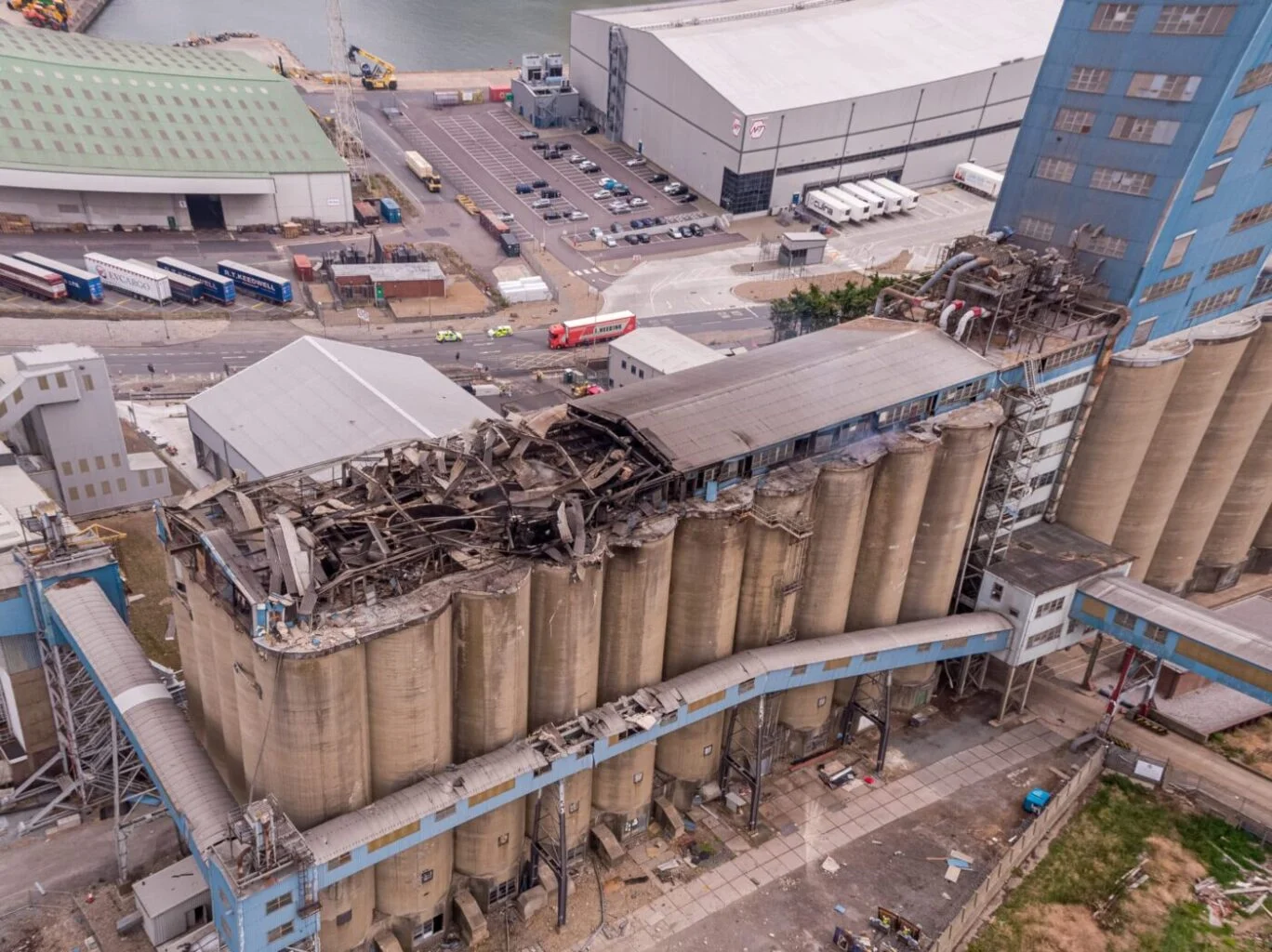
Thermal Fire Monitoring Following a Grain Store Terminal Explosion
Grain Store Explosion and Year-Long Fire – July 5, 2020 – Tilbury Port, London On July 5, 2020, a series of events (possibly by a spark) triggered a large dust explosion and a subsequent fire at the Grain Store Terminal at the Port of Tilbury in London. This was a serious event that required the attention of a large-scale emergency response to get the subsequent grain fire under control and avoid additional explosions. No one was seriously hurt, which is nothing short of a miracle given the number of people on the scene and the amount of reinforced concrete and debris thrown high into the sky before raining down on the surrounding buildings.
Traditional firefighting methods and techniques are ineffective in the case of grain storage fires. Using water to extinguish the inferno is ineffective with grain and dust fires, and the added weight might have caused a catastrophic structural collapse, exacerbating an already challenging situation. As a result, London fire teams were on the scene for days while a proper fire strategy and plan was developed and implemented, with staff always remaining on-site to monitor the situation over the following weeks.
Throughout this early period, there was always the possibility of more explosions and the fire spreading since the grain stored in the linked silos generates dust that may ignite if the temperature is high enough. Drone Media Imaging was contracted to fly thermal imaging flights to collect temperature data to estimate fire spread and track fire management efforts over time. For instance, were the temperatures rising, falling, or remaining constant?
We began operations on July 7, 2020, flying three flights each day, seven days a week initially, to compare temperatures and report back to crisis management teams and emergency service gold commanders. We eventually completed our thermal imaging missions one year and a month after the initial Grain Store explosion in late August 2021! While not all of the silos were full with grain, many were, and several were burning at temperatures far beyond 800°C. Before the fire could be quenched, the building had to be entirely demolished. Temperatures more than 80°C were still being recorded in the grain that remained on the ground after demolition 13 months later.
Gaining safe access to the terminal to fly was not without difficulty, as emergency services had imposed a 50m exclusion zone surrounding the terminal due to the possibility of additional explosions. As a result, our risk assessments and method statements had to be developed specifically for this circumstance and rigorously tested to assure both safe drone flights and the most accurate thermal data gathering at this vital juncture.
We continued to provide the Port of Tilbury London and the accompanying emergency services with daily and weekly calibrated temperature measurements that documented the progress of the grain store fire over 13 months. As thermal infrared aerial specialists, we provided data in the form of detailed reports, thermal imaging, RGB photographic and video footage.