Film Tourism is Great for the Drone Industry
The Growth in Film Tourism is Great for Drone Operators
Film and TV production is bringing huge benefit to councils, towns and cities across the UK by featuring landmarks and places of outstanding natural beauty as part of a ‘film tourism’ strategy.
The TV and film industry is supported by a competitive tax credit regime and due to an increase in high quality content form both traditional channels as well as the pay to view channels such as Netflix and Amazon, the public’s appetite for new movies and TV dramas is almost unquenchable.
Creative England are an organisation that have been working towards meeting the growing for drone footage as part of these productions and they have reached out in their summit on filming in the UK for more information on how to work with Drone filming professionals to get more involved.
Creative England are often the first people to get in touch with when productions are looking to film in the UK outside of London with the Production Services Department offering free comprehensive support to film and high-end TV productions.
Councils can look to receive income form areas such as those below although of course there are costs associated with these that must be covered from that revenue.

One area that Creative England are keen to promote is that of film tourism. The latest available statistics date back to 2014 but even these show an estimated value of £120-140 milllion for screen tourism outside of London. It’s fair to assume that these values have increased exponentially to the current time.
The use of remote camera technologies in filming and live broadcasting has become increasingly common and, as well as providing a bird’s eye view of the drama, aerial footage can also offer beautiful imagery of an area or building. Leaving aside the dramatic effects of setting the action in its wider environment, these shots can be amongst the most powerful when it comes to generating film tourist interest. Setting the scene or ‘general view’ by drone in the opening shots is now common place, it is a simple and cost effective way to establish a story’s location.
So, it is within the councils’ interests to allow aerial filming as part of these productions when it is requested. Unfortunately, some councils still seem to suffer from a lack of information about UAVs and the requirements for safe and legal drone operation. In some areas, this has led to a blanket ban on drone activity which is a loss both to a location’s filming potential and also to a council’s bottom line.
National Drone Network has extensive television and film industry experience within its membership. We are happy to work with local councils to create comprehensive drone policies that allow them to reach their full filming potential.

Expert Infrared Inspections for Accurate Thermal Assessments
Need professional thermographic analysis for your project? Our certified experts use the latest infrared technology to deliver precise results. Contact Drone Media Imaging today for expert thermal imaging services.
related posts

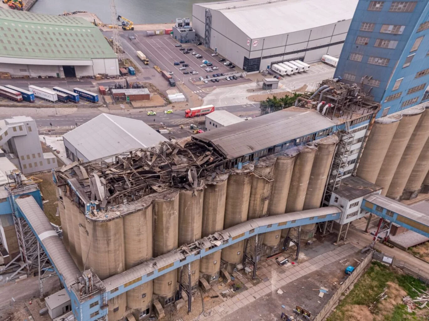
Thermal Fire Monitoring Following a Grain Store Terminal Explosion
Grain Store Explosion and Year-Long Fire – July 5, 2020 – Tilbury Port, London On July 5, 2020, a series of events (possibly by a spark) triggered a large dust explosion and a subsequent fire at the Grain Store Terminal at the Port of Tilbury in London. This was a serious event that required the attention of a large-scale emergency response to get the subsequent grain fire under control and avoid additional explosions. No one was seriously hurt, which is nothing short of a miracle given the number of people on the scene and the amount of reinforced concrete and debris thrown high into the sky before raining down on the surrounding buildings.
Traditional firefighting methods and techniques are ineffective in the case of grain storage fires. Using water to extinguish the inferno is ineffective with grain and dust fires, and the added weight might have caused a catastrophic structural collapse, exacerbating an already challenging situation. As a result, London fire teams were on the scene for days while a proper fire strategy and plan was developed and implemented, with staff always remaining on-site to monitor the situation over the following weeks.
Throughout this early period, there was always the possibility of more explosions and the fire spreading since the grain stored in the linked silos generates dust that may ignite if the temperature is high enough. Drone Media Imaging was contracted to fly thermal imaging flights to collect temperature data to estimate fire spread and track fire management efforts over time. For instance, were the temperatures rising, falling, or remaining constant?
We began operations on July 7, 2020, flying three flights each day, seven days a week initially, to compare temperatures and report back to crisis management teams and emergency service gold commanders. We eventually completed our thermal imaging missions one year and a month after the initial Grain Store explosion in late August 2021! While not all of the silos were full with grain, many were, and several were burning at temperatures far beyond 800°C. Before the fire could be quenched, the building had to be entirely demolished. Temperatures more than 80°C were still being recorded in the grain that remained on the ground after demolition 13 months later.
Gaining safe access to the terminal to fly was not without difficulty, as emergency services had imposed a 50m exclusion zone surrounding the terminal due to the possibility of additional explosions. As a result, our risk assessments and method statements had to be developed specifically for this circumstance and rigorously tested to assure both safe drone flights and the most accurate thermal data gathering at this vital juncture.
We continued to provide the Port of Tilbury London and the accompanying emergency services with daily and weekly calibrated temperature measurements that documented the progress of the grain store fire over 13 months. As thermal infrared aerial specialists, we provided data in the form of detailed reports, thermal imaging, RGB photographic and video footage.