Qualified to Category 2 Level Thermography
Drone Media Imaging Qualifies as Category 2 level Thermographers


We are delighted to announce that we are now qualified as Category 2 level thermographers!
Hot on the heels of our recent announcement about obtaining enhanced operating safety case permissions from the Civil Aviation Authority (CAA), we can confirm that we have now completed certification to deliver specialist aerial thermal imaging services to industry standards recognised by the British Institute of Non-Destructive Testing (BINDT), the BS EN ISO 18436 standard Category 2.
Moving on from our category 1 which certified us to collect thermal images as a calibrated and qualified operation, we are now certified to (in addition) deliver diagnostics, recommendations, and investigative reporting.
Category 2 Infrared Thermography builds on the category level 1 understanding of thermal physics, deepening and broadening our knowledge about infrared heat science, infrared measuring equipment, and its applications. Being able to offer a Category 2 level thermal imaging survey and inspection, along with our enhanced CAA permissions, puts us in a very small specialist group of a handful of businesses with such offerings in the UK. As Level 2 (CAT 2) Thermographers we can provide guidance to Level 1 (CAT 1) operators in the areas of equipment selection, techniques, limitations, data analysis, corrective actions, and reporting. So please get in touch if you need Category 2 reporting for your drone aerial inspections.
What can a Thermal Camera on a Drone Do?


Get in touch to find out how thermal imaging with infrared aerial cameras can help you with your project today.
We are certified and approved drone pilots with enhanced OSC permissions from the CASS. We work throughout the UK and provide both aerial and ground-based thermography services at a Category 2 level

Expert Infrared Inspections for Accurate Thermal Assessments
Need professional thermographic analysis for your project? Our certified experts use the latest infrared technology to deliver precise results. Contact Drone Media Imaging today for expert thermal imaging services.
related posts

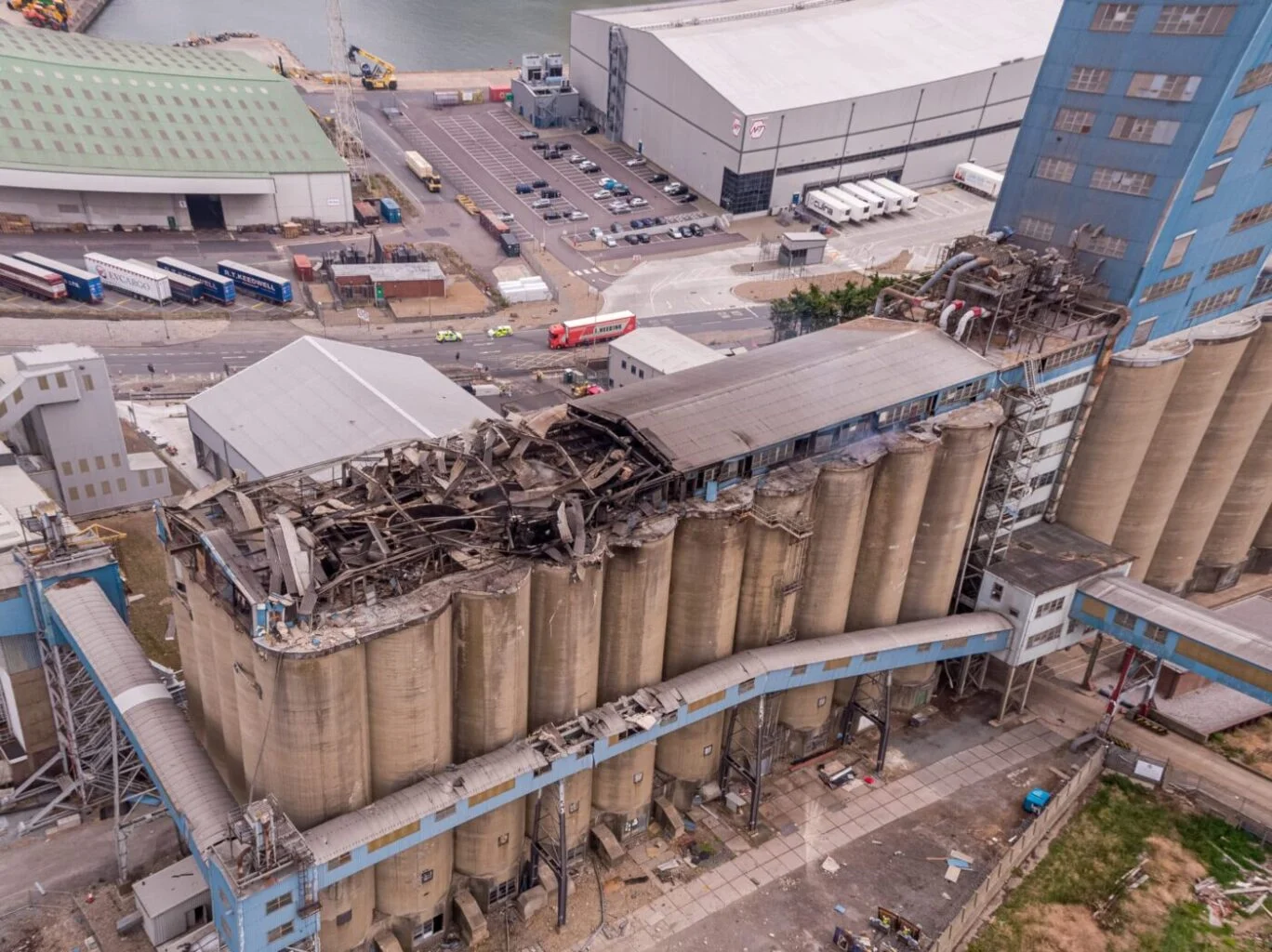
Thermal Fire Monitoring Following a Grain Store Terminal Explosion
Grain Store Explosion and Year-Long Fire – July 5, 2020 – Tilbury Port, London On July 5, 2020, a series of events (possibly by a spark) triggered a large dust explosion and a subsequent fire at the Grain Store Terminal at the Port of Tilbury in London. This was a serious event that required the attention of a large-scale emergency response to get the subsequent grain fire under control and avoid additional explosions. No one was seriously hurt, which is nothing short of a miracle given the number of people on the scene and the amount of reinforced concrete and debris thrown high into the sky before raining down on the surrounding buildings.
Traditional firefighting methods and techniques are ineffective in the case of grain storage fires. Using water to extinguish the inferno is ineffective with grain and dust fires, and the added weight might have caused a catastrophic structural collapse, exacerbating an already challenging situation. As a result, London fire teams were on the scene for days while a proper fire strategy and plan was developed and implemented, with staff always remaining on-site to monitor the situation over the following weeks.
Throughout this early period, there was always the possibility of more explosions and the fire spreading since the grain stored in the linked silos generates dust that may ignite if the temperature is high enough. Drone Media Imaging was contracted to fly thermal imaging flights to collect temperature data to estimate fire spread and track fire management efforts over time. For instance, were the temperatures rising, falling, or remaining constant?
We began operations on July 7, 2020, flying three flights each day, seven days a week initially, to compare temperatures and report back to crisis management teams and emergency service gold commanders. We eventually completed our thermal imaging missions one year and a month after the initial Grain Store explosion in late August 2021! While not all of the silos were full with grain, many were, and several were burning at temperatures far beyond 800°C. Before the fire could be quenched, the building had to be entirely demolished. Temperatures more than 80°C were still being recorded in the grain that remained on the ground after demolition 13 months later.
Gaining safe access to the terminal to fly was not without difficulty, as emergency services had imposed a 50m exclusion zone surrounding the terminal due to the possibility of additional explosions. As a result, our risk assessments and method statements had to be developed specifically for this circumstance and rigorously tested to assure both safe drone flights and the most accurate thermal data gathering at this vital juncture.
We continued to provide the Port of Tilbury London and the accompanying emergency services with daily and weekly calibrated temperature measurements that documented the progress of the grain store fire over 13 months. As thermal infrared aerial specialists, we provided data in the form of detailed reports, thermal imaging, RGB photographic and video footage.